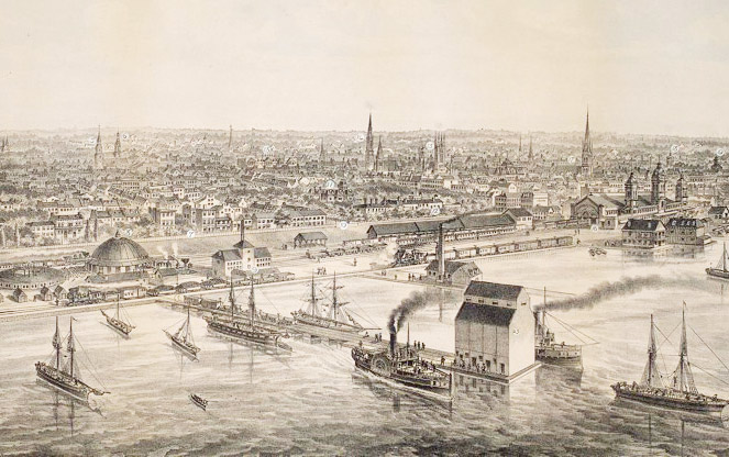
 City of Toronto Bird's Eye View from the Northern Railway elevator, 1876. Drawn by G. Gascard. Image courtesy Toronto Public Library
From its Beginnings to 1900
of Toronto.
Established as the Town of York in 1793 by British Lieutenant Governor John Graves Simcoe, occupation of the area known as Toronto dates back centuries earlier with indigenous encampments. Since the retreat of the last continental glacier more than 10,000 years ago, Southern Ontario was used as hunting territory, with multi-tribal settlements first established some 5,000 years ago. These people created an overland route between Lake Ontario and the Georgian Bay to the north, later used by French fur traders in the early seventeenth century. The name of this trail, alternatively called the “Toronto Passage” and the “Toronto Carrying-Place Trail” derives from an Iroquoian term that translates to “place where trees stand in water.” At the southern extent of this trail where the Humber River drains into Lake Ontario, the French established an outpost in 1720. Thirty years later and five kilometers east, the French military constructed Fort Rouillé, which they subsequently burned less than a decade later in their retreat from British forces that resulted in the establishment of English rule.
The province of Upper Canada was founded in 1791 and, shortly thereafter, Simcoe established the town of York on the heavily wooded shoreline of Lake Ontario. Simcoe garrisoned Fort York to guard the harbor and laid out the north-south Yonge Street and the east-west Dundas Street, accommodating settlement, trade, and defense. The town was organized into a grid of ten square blocks with sections for the military (the Garrison reserve), the parliamentary government, residential dwellings, and the wharf. The Township of York, like the rest of lands north of Lake Ontario and Lake Erie, was laid out with a grid of public concession roads and farm lots to promote settlement. Lot Street (now Queen Street) was laid out north of the town parallel to the harbor and the lands between Lot and Bloor Streets were divided into 32 so-called Park Lots for large estates. Township lots were separated by the grid of concession roads and laid-out to maximize access to water—these were oriented east-west near the Humber River on the west and the Don River on the east and, lining Lake Ontario, the lots were established north-south. The subsequent sub-division of each lot was done by the landowner without reference to topography or context. This grid, followed by the patchwork evolution of subdivisions— each with its own character— gives Toronto its unique physical character.
Front Street followed the shore line of the harbor joining the town with the fort. This street became the location of many of the first important and public buildings including the Parliament, St. Lawrence Market and the Palace of Bishop Strachan, the leader of the family compact. Simcoe, taken by the picturesque qualities of the shoreline, envisioned an extensive park stretching between the Garrison reserve on the west to King’s Park near the Don River on the east that would provide public space for York’s residents and conserve the natural qualities of the waterfront. The Walks and Gardens Trust was founded in 1818 to secure the land, but with a cholera outbreak in the 1830s, the Garrison reserve was subdivided and sold to fund the construction of a hospital and King’s Park was in-filled due to health concerns.
Shortly before his death in 1830, landscape gardener André Parmentier brought more than 500 pink chestnuts from his nursery in Brooklyn, New York, to line a carriageway leading to the King’s College at York (today the University of Toronto - St. George) campus established by Royal Charter in 1827. The town of York was renamed Toronto in 1834 and the city continued to evolve. Streetcar lines, sewers, and gas lighting accompanied the rise in population. Markets—such as the two-hectare St. Lawrence Market established in 1803 and largely built-out with a brick town hall by the 1840s—were established on the wharf and churches, schools, and governmental buildings were constructed. In 1842 celebrated author Charles Dickens visited North America and, though unimpressed with what he observed in the United States, wrote that Toronto “itself is full of life and motion, bustle, business, and improvement.” Of Parmentier’s carriageway, Dickens remarked, “It will be a handsome, spacious edifice, approached by a long avenue which is already planted and made available as a public walk.”
By the 1850s one of Toronto’s most significant features—its extensive system of ravines—had been drastically altered by logging and industrial uses. The Lower Don River Valley, at the mouth of Toronto’s largest ravine, saw the greatest exploitation, while other smaller ravines were capped by the development of the city and used as sewers. In 1852 the Grand Trunk Railway Company of Canada was incorporated to construct a route connecting Toronto to Montreal, 500 kilometers to the east, and the Georgian Bay to the north via the Toronto Passage. Architect John Howard developed plans for parks along the waterfront, though most of these were not implemented and, instead, the building of the railroad on landfill south of Front Street severed the city from the shoreline. As the railroads grew, so too did dirt, noise, and pollution associated with industry-- thus, public buildings and their associated landscapes moved further north into the heart of the city. Many of these buildings, parks, and gardens followed a tradition of locating at the end of a north south street facing the water.
John Stoughton Dennis, after surveying land for the railroad, registered plans for the Rose Park (now Rosedale) subdivision at the northeastern corner of Yonge and Bloor Streets in 1854. This unique subdivision of picturesque curved streets was set apart from the city by the Rosedale Ravine. Suburban development, made possible by the streetcar (horse-drawn until the 1890s), allowed people to move away from the urban core; subdivided lots were created until 1857 when the economic boom stalled. Part of the King’s College campus was leased to the City of Toronto in the late 1850s and its Picturesque grounds laid out by William Mundie and Edwin Taylor—bordered by Taddle Creek and McCaul’s Pond and punctuated by pines, maples, elms, and oaks—was used as a public park, eventually flanked by the Romanesque Revival Ontario Legislative Building. In 1858 Allan Gardens was established in the Garden District neighborhood east of downtown. Victorian Gardenesque horticultural gardens and conservatories were laid out by landscape gardener Edwin Taylor (redesigned 100 years later by Modernist landscape architect J. Austin Floyd).
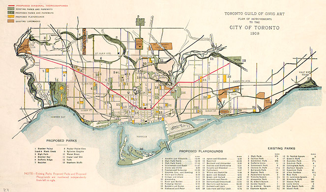 Plan of improvements to the City of Toronto. Image courtesy Toronto Public Library
From 1900 to Today
By the 1860s the Gooderham and Worts Distillery Complex (established in 1837) was North America’s largest distillery. Similar to other industry on the waterfront, the growth of the complex led to extensive in-filling, effectively extending the shoreline into Lake Ontario. The reclamation of land was mirrored nearby by the stabilization of sandbars forming the Toronto Islands, which witnessed the construction of amusement parks, hotels, and cottages as early as the mid-1860s. This development coincided with the beachfront development at Kew Gardens, a Picturesque seasonal resort offering accommodations to summer campers and boarders. In 1867 Toronto was made the capital of Ontario, the population was growing and diversifying, and the port, flanked by the railroad, was becoming increasingly industrialized. In 1900 the Timothy Eaton Company built an underground pedestrian tunnel to connect its main store with an annex at Yonge and Queen Streets. By 1927 this was connected to Union Station, expanding rapidly in the 1970s, and now comprises the 29-kilometer PATH network of interconnected passageways and retail space.
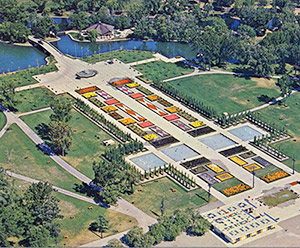
In 1904 the Currie Building in downtown Toronto burst into flames, eventually engulfing eight hectares. From the ruins of that fire, a new skyline emerged, constructed largely from bricks created at the Don Valley Brickworks established in 1889 (now a heritage property designated under the Ontario Heritage Act and home to the Weston Family Quarry Garden and the non-profit Evergreen Brick Works). The Toronto Financial District and the Eaton’s 24-hectare complex of warehouses and stores were enlarged as part of that renewal. Coincident with the City Beautiful movement at the turn of the century, the Toronto Guild of Civic Art—comprising elite businessmen, artists, and architects—was established to guide city planning and promote the conservation of natural surroundings, though by then much of the shoreline had been significantly altered. Influenced by the 1893 World’s Columbian Exposition, the Canadian National Exhibition was established in 1904 and, in 1920, a Beaux-Arts master plan for the Exhibition Place campus was designed by the architectural firm Chapman and Oxley on reclaimed land near the former location of Fort Rouillé.
Toronto experienced a boom in construction and population through the 1920s, resulting in the continued development of urban Toronto and its suburbs. In 1907 businessman Wilfred Dinnick established Lawrence Park, a Garden City suburb laid out by British surveyor Walter Brooke with landscape architects Howard and Lorrie Dunington-Grubb. In 1913 some 400 hectares of agricultural land northeast of the city center was transformed into the Picturesque suburb of Leaside, designed by Frederick Todd (an apprentice of Frederick Law Olmsted, Sr.) for the Canadian Northern Railway. Development stalled in the Great Depression, lasting through World War II, though historic preservation work at Fort York was undertaken from 1932 to 1934. Amid the housing shortage and increase in population that followed World War II, the Modernist Don Mills Neighborhood was designed by Macklin Hancock according to Garden City principles. In 1954 the first twelve stations of Toronto’s network of elevated and belowground transit system opened on the Yonge Street line— today expanded to nearly 70 stations along more than 65 kilometers of track.
Disastrous flooding associated with Hurricane Hazel, also in 1954, led to a greater awareness of the vulnerability caused by the deforestation and channelization of Toronto’s ravines. Three years later, the Metropolitan Toronto and Region Conservation Authority was formed to manage watersheds and to create recreational opportunities in an area of more than 16,000 hectares. Subsequently, the Authority expropriated land and enacted development restrictions of the watersheds along Etobicoke, Mimico, and Highland Creeks and the Don, Humber, and Rouge Rivers. In 1955 businessman Rupert Edwards sold his eleven-hectare estate in the Wilket Creek ravine to the City of Toronto to be used as a public park and arboretum, now home to the Toronto Botanical Garden established by the Garden Club of Toronto in 1958.
Tracing the waterfront, after more than a decade of planning, the construction of the Gardiner Expressway paralleling the railroad commenced in 1955, further separating the city from Lake Ontario. Closer to downtown, the formation of the Toronto-Dominion Bank, also in 1955, led to a major redevelopment of the Financial District: With the razing of historic structures (save the Art Deco Toronto Stock Exchange Building), Ludwig Mies van der Rohe was selected to develop a 3.35-hectare site, with the first phase completed by Canada’s Centennial in 1967. Serving as a forecourt to Toronto City Hall, the 4.85-hectare Modernist Nathan Phillips Square designed by Vilijo Revell and Richard Strong includes a reflecting pool and multi-level plaza. Also at this time a short distance from City Hall near Queen’s Park, the short-lived firm of Sasaki, Strong and Associates designed a Modernist courtyard, plaza, and rooftop garden to encompass an entire city block. Known as the Queen’s Park Complex and designed as an annex to the Provincial Legislature, the campus comprises pools and fountains, public sculpture, planting beds, and groves of crabapple, birch, and Russian olive.
The 1970s brought urban renewal and many old neighborhoods were demolished to create denser, more modern ones organized around large landscaped open spaces; these include Regent Park and St. Jamestown. At the same time, transformation of the waterfront began. Inspired by the 1967 International and Universal Exposition in Montreal, Ontario Place opened in 1971 adjacent to Exhibition Place. Designed by Eberhard Zeidler, Michael Hough, and Eric McMillan, the interconnected ensemble of architectural, engineering, and landscape features was constructed on two constructed islands in Lake Ontario. Nearby, Harbourfront Centre transformed warehouses into mixed-use commercial and residential quarters and formerly industrial land into a series of landscaped parks and plazas. The 1980s saw the construction of the Modernist Mel Lastman Square to provide civic space adjacent to the North York Central Library and City Hall, the most elaborate of the civic centers for the smaller municipalities that made up Toronto including North York, East York, York, Etobicoke, and Scarborough.
A remnant of the former Garrison reserve that served as the Lakeshore Psychiatric Hospital from 1889 to 1979 was transformed into the 78-hectare Colonel Samuel Smith Park, a wetland and wildlife habitat comprising reclaimed land on the shores of Lake Ontario. In 1994 the Postmodernist Village of Yorkville Park was completed by Oleson Worland Architects and landscape architects Martha Schwartz, Ken Smith, David Meyer, and Peter Walker + Partners. Yorkville, founded in 1830 and annexed by the City of Toronto in 1883, was the bohemian center of Toronto in the 1960s, though over the course of the next 20 years transitioned into high-end boutiques and condominiums. The Village of Yorkville Park, which won the American Society of Landscape Architects Landmark Award in 2012, reflects the diversity of the Canadian natural landscape with extensive plantings, elevated boardwalks crossing a wetland, and a 650-ton granite rock imported from the Canadian Shield.
 Harbour Square Park, 2014. Photo © William Yiu
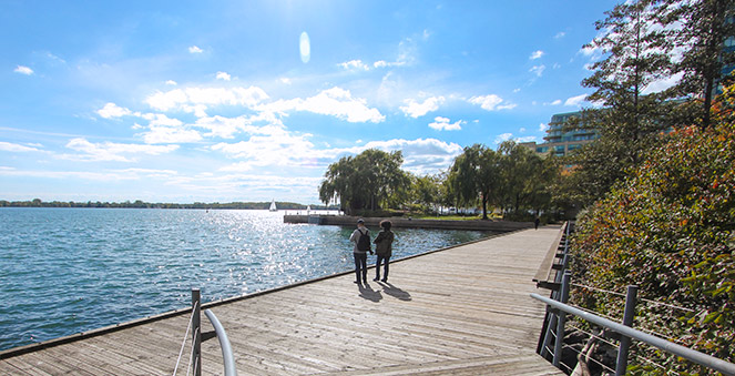
Revitalization of the waterfront is on-going, with new parks and amenities such as HtO, Sugar Beach, Corktown Common, Sherbourne Common, and Water’s Edge Promenade serving to reconnect Toronto to the shoreline. In 2001 the federal, provincial, and metropolitan governments formed the Toronto Waterfront Revitalization Corporation (now Waterfront Toronto) to implement economic and programmatic renewal. Today, alluding to its more than 1,400 parks and extensive system of ravines, Toronto is appropriately dubbed the “City within a Park.” With a multi-ethnic population of more than 2.5 million, Toronto is the fourth most populated city in North America. The international implications of planning this megacity—at once historic and modern, regional and global—require a thoughtful approach that acknowledges the city’s unique and irreplaceable cultural landscape.


