

TCLF Launches New ‘What’s Nearby’ Feature
Want to discover what landscapes are within a ten-minute walk from where you're presently standing? The Cultural Landscape Foundation's (TCLF) 'What's Nearby' function has been updated with new information and improved graphics to make finding cultural landscapes even easier.

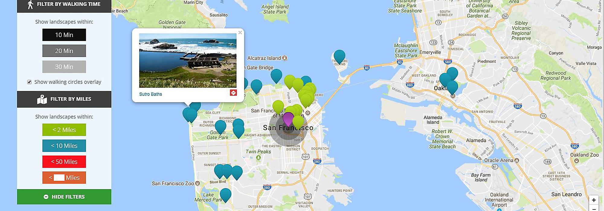
TCLF has long provided visitors to its website with an interactive online feature called ‘What’s Nearby,’ which functions in two different ways. First, it allows users on TCLF’s homepage to see cultural landscapes in the What’s Out There database that are in the vicinity of the user’s current location. In that way, individuals accessing the website can be directed, at the click of a button, to nearby landscapes, along with links to essays about their design history and designers. The ‘What’s Nearby’ feature also allows users to see the landscapes that are in close proximity to each other, regardless of the user’s location—perfect for research or for planning a day of exploring a city or region.

Working with the Washington, D.C.-based web design and development company Fionta, TCLF has substantively upgraded the ‘What’s Nearby’ feature to provide a much richer and customizable user experience. Before, the nearby landscapes were displayed with uniform visual properties within a fixed radius of 25 miles. Now, users can choose to see those landscapes that are within 2, 10, or 50 miles of a given location (with the sites presented in a color-coded display) or they can customize the search by inputting the mileage of their choosing. The density of sites in the What’s Out There database varies widely by location (usually a product of where a What’s Out There Weekend was held or a City Guide has been developed). There are many more landscapes near Central Park, for example, than, say, Acoma Pueblo, in New Mexico. The new custom distance option gives the user the ability to tailor the search results to their particular location. A pop-up image of the selected landscape gives a preview of the site and then maps the best route to reach it.

The new feature also allows users to filter the nearby landscapes according to walking time, in increments of 10, 20, or 30 minutes, roughly corresponding to distances of 0.5, 1, and 1.5 miles. This new function is meant to encourage the exploration of the urban environment on foot. The added functionality of the ‘What’s Nearby’ feature is further enhanced by maps that automatically re-scale with changes in mileage or walking time, ensuring a more intuitive user experience.
“One of the biggest challenges with Google Maps and other online map services is that the scale is nearly infinite, which can make it difficult to understand how an inch on the screen translates into real travel time and distance, especially with the zoom functionality of electronic maps. We wanted to provide an easier, more intuitive way to use the ‘What’s Nearby’ feature to access the more than 2,000 cultural landscapes in our database,” said Barrett Doherty, TCLF’s visual content director.
The new ‘What’s Nearby’ feature was launched in early February 2018, and its scope will automatically expand with each new landscape entered into TCLF’s database.

