


Landscape Information
This 1299-acre park on the southwest bank of the Potomac River was one of the original six parks designated for Virginia’s state park system in 1936. Situated at the geological transition of the Upper Coastal Plain and the Tidewater regions, the site—formerly used for timber harvesting— was identified by Department of Conservation and Development Landscape Engineer Robin (Bob) Burson and developed by the Civilian Conservation Corps (CCC) in accordance to design guidelines developed by the National Park Service.
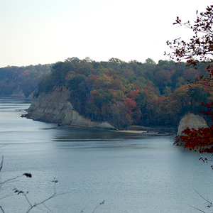
Between 1933 and 1942 the CCC constructed roads and numerous structures, developed campsites and facilities, and built six miles of trails to access the park’s natural landscape. The north-south entry road, divided by a planted median, passes through two miles of hardwood forest and meadows before terminating at parking areas near the Potomac. Spur roads access campsites positioned on undulating topography, encircled by trees, and characterized by fire rings, picnic tables, and bathhouses. The CCC also developed several cabins on a ridge overlooking a ravine, two picnic shelters, and a restaurant on the river. A sandy beach west of the dramatic Horsehead Cliffs is protected by rock and timber bulkheads and, in 1934, the CCC constructed a dam and pond connected by a creek to a water filtration plant.
Additional cabins and campsites as well as a visitor center were added in the post-War years; a contact station and swimming pool were added in the 1970s and 80s respectively. Westmoreland State Park was listed in the National Register of Historic Places in 2005.